An important factor in project progress is a thorough examination of all necessary inputs, including the actual spatial arrangement of the essential parts of the existing technology. The absence of accurate information about the space and also the objects located in it may cause unexpected implementation problems. Deviations from the project design mean for the investor an increase in implementation time, costs, as well as additional personnel expenses.
At ENSECO, a. s., we can largely prevent these issues. Thanks to 3D laser scanning, a new feature in our engineering and design services portfolio, you will save not only time, but also costs associated with increasing the budget and eliminating errors resulting from the provision of inaccurate documents describing the current state of technology.
What is 3D laser scanning?
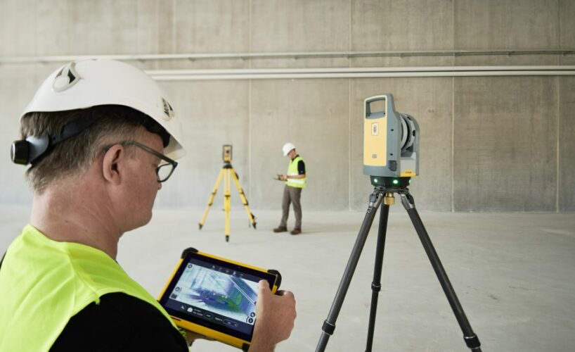
TRIMBLE X7 is a highly sensitive 3D scanner that can record real objects in space, their complex parameters, and then display the exact visualization and location of these objects in the local coordinate system. With the known S-JTSK points, we can also place the scan in the national geodetic network.
The scanner operator scans the so-called “point clouds”, which display objects in the interior or exterior. They contain precise information about 3D dimensions, volumes, as well as mutual spatial arrangement. A technological innovation in the field of scanning is the ability to capture highly reflective objects and hard-to-reach places that have been difficult to capture so far (radiance, inaccessible terrain, danger of approaching the object, etc.).
By post-processing with technology modelling and imaging software, you get a visualization in commonly available formats and outputs, without the need to use any other special software.
3D scanning enables a big shift in design and planning
How can the obtained data influence other project processes? A comparison of the actual state with the project documentation will reveal the deviations that arose during implementation. Thus we are able to reveal and eliminate potential weak points and problems before the technology/device/system is launched. TRIMBLE X7 brings more efficient and detailed mapping of the actual state, in comparison with e.g. geodetic surveying. Scanning technology and speed makes the entire process of detecting the actual state more efficient and saves time and money.
Our clients can benefit from the detailed 3D models in new project planning or in transforming their existing projects into actual-state visualizations. The advantage is a faster and more modern planning without unexpected collisions or costly deviations from the actual state.